


The HGR receiver and its technology is an economic solution that integrates various sources of information ensuring accuracy, sturdiness and precision that currently no other receiver can provide. The key driver for HGR application class is the ability to detect spoofing and meaconing, therefore determining the authenticity of the location-related data. The system exploits the use of three sources of information, as follows:
- The GNSS, for continuous, accurate and worldwide available timing and positioning services;
- The ADS-B, as source of a priori unknown messages in terms of content, signal characteristics (e.g. the actual bits of the message) and emission time. By design, in fact, ADS-B messages are transmitted by each airplane at random times, in order to avoid message conflicts in accessing the shared ALOHA channel at 1090 MHz (ADS- B is based on a pure ALOHA access);
- A secure synchronisation mechanism based on a communication network, to provide alternative timing through a secure channel.
![]()
The unique combination of the three elements above, or part of them when not all are available, provides capabilities to detect the most likely spoofing attacks, i.e. those based on “signal retransmission” (meaconing) and even those based on “signal simulation”.
The target user can be resumed in three different categories:
1. Consortia and logistics and transport companies
2. Industries producing Black Boxes and GNSS Receivers.
3. ISVAP (Institute for the supervision of private and collective interest insurance) and some insurance companies, always in the capacity of stakeholders.
The users engagement envisaged in the project are 4 transport and logistics companies. Through interview and questionaries’ it seems an important security insight emerged about special on road transport categories (i.e. electronics, jewellery, money transport etc). In any case, to monitor the transports in real time, the means are often connected via geolocation services that exploit GPS signals and web connectivity despite there being signal interruption problems.
The relevant applications and user needs for Road Domain:
- Safety-Critical Applications (SCA)
---> Fleet Management – enhanced (HMT)
- Payment-Critical Applications (PCA)
---> Location-based charging (RUC)
---> Pay-As-You-Drive
- Regulatory-Critical Applications (RCA)
---> Emergency Services – eCall
---> Road Navigation – supporting emergency
---> Vehicle Tracking – DT
- Smart Mobility Applications (SMA)
---> Road Navigation
---> Fleet, asset and freight monitoring
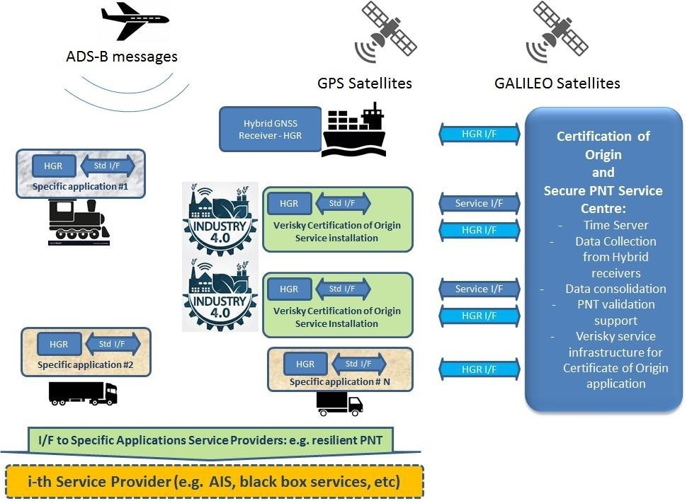
The key driver for HGR application class is the ability to detect spoofing and meaconing, therefore determining the authenticity of the location-related data. The system concept is to acquire the same signals from different sites by means of collaborative receivers and/or reference receivers managed by the service owner. Every receiver, knowing its presumed position by using GNSS, is able to infer the emission time of an ADS-B message, which can be compared with the similar evaluation made from all receivers who decoded the same message. At this point, the system is able to verify the trueness of the presumed position of each receiver by using a voting mechanism (with reference receivers having very large weight in the evaluation). The comparison with GNSS derived position shall allow to validate and to certify GNSS positioning against spoofing. The proposed architecture considers the possibility to interoperate with Service Providers already supporting the Transportation Chains (e.g. fleet management systems).
The HGR will provide two sets of information, as described below:
- The position, as any GNSS receiver (e.g. using NMEA protocol)
- The level of confidence associated to the information reported, including alarms when a spoofing, meaconing or jamming attack is detected, e.g. extending the NMEA protocol.
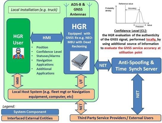
The system is composed by:
- A set of HGR equipment, installed on the transportation platforms for rail, road and maritime smart transportation (respectively on trains, trucks or vessels)
- The Anti-spoofing and the time synch server(s) to manage the systems and services
The proposed application/service takes advantage of GNSS signals, especially Galileo, the Europe’s own global navigation satellite system. Currently providing Initial Service, Galileo is designed to be interoperable with GPS and GLONASS, the US and Russian GNSSs. In detail, Galileo is introducing a new service, referred to as Open Service Navigation Message Authentication (OSNMA), designed to be disseminated over the E1 band. This functionality contributes significantly to mitigate the simplest forms of spoofing attacks, which are also the most likely. Whereas GNSS remains the principal mean for positioning, especially in outdoor scenarios, highlight risks related to GNSS spoofing and jamming.
The HGR is based on the exploitation of a patented anti-spoofing algorithm based on the integration of data coming from three different sources of information: positioning technology (GNSS), Signals of Opportunity (SoO) (ADS-B) and a satellite-independent timing source. This unique combination of the three elements above, or part of them when not all simultaneously available, provides capabilities to detect the most likely spoofing attacks, i.e., those based on “signal retransmission” (meaconing) and those based on “signal simulation”. Such a combination grants benefits against intentional spoofing attempts.
 ,
,
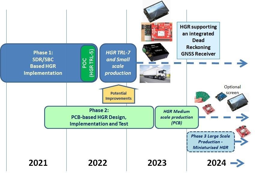
The HGR development status in March 2021 is the following:
- Consolidated user requirements
- Consolidated HGR design baseline
- Started HGR prototyping activities with the support of strategical partners: LINKS Foundation, a research centre, and INRiM, a public research centre and Italy's national metrology institute (NMI)
- Started simulations to determine expected performance. Initial results shows very good performances, in line with the requirements, achieved with margin
- Prototype results are consolidated within June 2021
-Implementation is planned to be completed by spring 2022
- Proof Of Concept with installations on vehicles are scheduled, using the implemented system, in Summer 2022. The POC are organised with the involvement of target users and stakeholders